Title
Big Pamir Land Classification Map
Author(s)
Bedunah, D. J. and H. Rahmani
Abstract
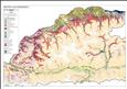
Based on ground-truthing data gathered in Wakhan by the WCS Rangeland Assessment Team in 2008, the GIS Team developed a detailed map of the results, dividing up the Big Pamir area into 24 different biotic and abiotic classes. A Landsat TM 30m resolution classification was also used. The map is downloadable in pdf format here.
Keywords
Big Pamir, land classification, Wakhan corridor, GIS, rangeland assessment
Access Full Text
Back
DMX624900000